DigDag is a digital atlas of Denmark’s jurisdictions since the 1600s. The atlas covers many types of jurisdictions and authorities, including parishes, medical districts, courts, and military jurisdictions. Learn how to use it to assist you in your Danish family history research.
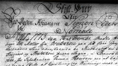
The Webinar Short “Find the Right Historical Jurisdiction in Denmark Using the Website DigDag” introduces genealogists to DigDag, the Digital Atlas of Denmark’s Historical Administrative Geography. It explains how shifting boundaries and layered jurisdictions—ecclesiastical, judicial, medical, cadastral, and civil—shape where records were created and where they can be found today. By demonstrating practical searches and real-world pitfalls (such as parishes changing streets at specific dates), the session shows how to translate a place and time into the exact authority that held the records, turning vague location clues into targeted research paths.
DigDag’s core tools are presented in a researcher-friendly sequence. The Regular Map highlights a single jurisdiction type (e.g., judicial or parish) on a specific date using a year slider or typed date, revealing which authority covered a location at that moment. The Double Map compares two dates or two jurisdiction types side-by-side, making boundary changes visible—perfect for explaining why a birth or baptism might “disappear” from an expected parish register after a reorganization. The Place-Name Search is the fastest route when the exact location is uncertain or spelling is in doubt; results open a details page with expandable sections for superior (Overordnede) and subordinate (Underordnede) jurisdictions. Those hierarchies point to additional record sets—diocesan, county, court (birks), medical districts, and cadastral units (Ejerlav) used to locate historical maps and land-based sources.
Because the interface is Danish-only, the webinar emphasizes smart searching: use Danish terms (e.g., Sogn for parish), apply wildcards (* for multiple letters, _ for a single character or missing Danish letter), and leverage variant spellings to surface both historic and modern forms. Practical navigation tips (zooming, recentering, and quick page reset) keep the focus on research rather than interface friction. Throughout, examples illustrate how a street’s parish affiliation can change year-to-year, guiding researchers to the right book, register, or district office for each event.
See boundary shifts instantly with Double Map to explain “missing” civil or church entries after a re-parishing or re-districting.
Use the jurisdiction hierarchy to move up or down levels and uncover new record types—court, medical, cadastral, and diocesan—beyond parish books.
Search efficiently in Danish with wildcards and official names to catch historical spellings and modern variants.
Ready to pinpoint the exact office that kept your ancestor’s records—and why they moved? Watch the full Webinar Short and explore the resource to see each technique in action, with step-by-step demonstrations that accelerate Danish research. After viewing, don’t miss the syllabus extras, including the Danish–English word lists and supplemental links, to deepen searches and make navigating DigDag faster and more productive.


 Syllabus


Comments
To leave a comment, please tell us who you are
Already a member? Log in